
The Forgotten River
How the Water of Cruden Changed CourseThe River That Remembered
Stand on the footbridge beside Port Erroll Harbour and watch the Water of Cruden make its final journey to the sea. It flows quietly beneath the bridge before turning south into Cruden Bay, following a route so familiar that few people ever question it.
Yet the landscape suggests that the river has not always flowed this way.
A short walk along the coastal path towards Slains Castle brings you to a place with the curious name of Old Water Moo’. Here, the modest Back Burn winds through a broad, gently sloping valley before disappearing into a deep rocky gorge on its way to the North Sea.
At first glance, nothing seems unusual.
Look a little more closely, however, and something begins to feel out of place.
The valley appears far too wide for such a small burn. The gorge seems far too substantial to have been carved by the gentle trickle that occupies it today. Instead, the whole landscape has the appearance of an abandoned river valley — one created by a much larger volume of water over many centuries.
It’s an observation that has intrigued local people for generations.
Was there once a much bigger river flowing here?
If so, where did it go?
The answer isn’t hidden beneath the soil or buried beneath the cliffs. It survives in plain sight, preserved in the shape of the land itself, in forgotten place names, in centuries-old maps, and in the notes of Victorian surveyors who recorded what local people still remembered.
Together they tell the remarkable story of a river that once reached the sea by a completely different route.
A river whose original course was never entirely forgotten.
Every place has its stories, and some are best told in song. As part of our continuing exploration of Cruden Bay’s history, we have created an original folk ballad, The Forgotten River, inspired by evidence uncovered during this investigation. The song weaves together the landscape, old maps, and memories preserved by local people, following the tradition of travelling singers who once carried history from one generation to the next.
The video below features the ballad alongside aerial footage tracing the historic route of the Water of Cruden, as outlined in the illustration opposite. It follows the river’s former course across the reclaimed ground where the car park now stands and onward through Castle Woods. After reaching the sea, the footage continues along the coastline towards the present-day river mouth beside Port Erroll Harbour, before returning towards the Dardanelles.
When the Water of Cruden Flowed North
If the broad valley leading towards Old Water Moo’ really was once the course of the Water of Cruden, there should be some evidence beyond the landscape itself.
There is.
Long before aerial photography or satellite images, mapmakers carefully recorded the rivers, roads and landmarks they found on the ground. Although each survey was produced for a different purpose, they all tell the same story.
The earliest comes from William Roy’s Military Survey of Scotland, carried out between 1747 and 1755. Compiled in the years following the Jacobite Rising, Roy’s map clearly shows the Water of Cruden continuing north-east before reaching the sea at what is now known as Old Water Moo’.
Remarkably, later mapmakers recorded exactly the same course. James Robertson’s Map of Aberdeenshire (1822) again shows the river flowing north to the coast, while John Thomson’s Atlas of Scotland (1832) independently confirms the same route.
Three surveys. Three different cartographers. Nearly a century apart.
Each records the Water of Cruden reaching the sea well north of its present mouth.
When these historic maps are compared with the modern map, the reason becomes immediately clear. The former river course follows almost exactly the same broad valley now occupied by the much smaller Back Burn. The river may have gone, but the landscape it shaped remains unmistakable.
Taken together, the maps provide compelling evidence that, for centuries, the Water of Cruden followed a very different journey to the sea. The question was no longer where the river once flowed.
The real mystery was why anyone would choose to move it.

James Robertson’s Map of Aberdeenshire (1822)

John Thomson’s Atlas of Scotland (1832)

Current View (2026) – Open Street Map
When the River Changed Course
At some point during the nineteenth century, the Water of Cruden abandoned the route it had followed for countless generations. By the time the First Edition Ordnance Survey was completed in the early 1870s, the river no longer flowed towards Old Water Moo’. Instead, it followed the course we know today, turning south before entering the sea beside Port Erroll Harbour.
Somewhere between John Thomson’s map of 1832 and the Ordnance Survey forty years later, the landscape had been deliberately altered.
The strongest evidence comes not from the maps themselves, but from the surveyors who walked the ground while preparing the new Ordnance Survey. As well as measuring the landscape, they carefully recorded local place names and gathered information from people who knew the area well.
Among their notes is a remarkable description of Old Water Moo’, identifying it as:
“…a sea inlet into which the Water of Cruden formerly discharged.”
Those few words tell us something extraordinary. The diversion was not some ancient event lost in history—it was recent enough for local residents to remember. The surveyors were told that this quiet inlet had once carried the full flow of the Water of Cruden, and they considered that local knowledge reliable enough to include in the official record.
The Name Books also reveal that the information came from respected local sources, including James Mitchell, Robert Mitchell and James Paterson, and that the surveyors referred to an Estate Plan dated 1857 while compiling their descriptions. Although no surviving engineering plans have yet been found, the documentary evidence leaves little doubt that the river’s course had been deliberately changed before the survey was completed.
For the first time, the maps, the landscape and the memories of local people all come together. They reveal not only where the Water of Cruden once flowed, but also that the diversion was remembered as part of the living history of Cruden Bay.
“This originally was the mouth of the Water of Cruden, but some years ago the course was altered and now it runs into the Sea at the Ward.”
— Ordnance Survey Name Book, Parish of Cruden (OS1/1/22), c.1871

Figure 4. First Edition Ordnance Survey (c.1872).
Why Divert the River?
Moving the course of an entire river was no small undertaking. It would have required careful planning, considerable labour and, above all, a very good reason.
Although no document has yet been discovered explaining exactly why the Water of Cruden was diverted, the timing of the work offers an important clue.
During the middle years of the nineteenth century, Port Erroll was changing rapidly. The harbour was being improved, the fishing village was growing, and increasing numbers of boats depended upon a safe and reliable entrance to the sea. Like many harbours around Britain’s coast, however, Port Erroll faced a constant battle against sand. Waves and tides carried sediment into the harbour mouth, where it could build up into shallow banks that restricted access for fishing vessels.
One of the simplest ways of helping to keep a harbour clear was to make use of a river. A steady flow of freshwater passing through the harbour entrance helped wash sand and silt back out to sea, reducing the need for continual excavation. By redirecting the Water of Cruden to enter the sea beside the harbour, Victorian engineers may have found an elegant solution to an ongoing problem.
The theory fits the evidence surprisingly well. Historic maps suggest the diversion took place at the very time Port Erroll was being developed, while the former river channel was left to the much smaller Back Burn. The growing village also gained a more convenient river crossing and improved drainage across the low-lying land surrounding the harbour.
Until further documentary evidence comes to light, we cannot say with complete certainty that harbour improvement was the sole reason for the diversion. It may have been one objective among several. But viewed against the wider transformation of nineteenth-century Port Erroll, the idea makes compelling sense. The river was not diverted simply for the sake of changing its course—it became part of a much bigger vision for the future of the village.
A Landscape That Still Remembers
The Water of Cruden has followed its present course for well over a century. Generations have grown up knowing the river exactly as it is today, flowing beneath the bridge before entering the sea beside Port Erroll Harbour. To most people, it seems the most natural thing in the world.
Yet the landscape quietly tells a different story.
Walk from the harbour towards Slains Castle and you’ll soon reach the broad valley leading to Old Water Moo’. The little Back Burn still makes its way through the ancient gorge, following the path once taken by the full flow of the Water of Cruden. Look carefully and the clues are everywhere. The valley is too wide for the burn that now occupies it. The gorge is too substantial to have been carved by such a modest stream. Once you know what you’re looking at, the evidence becomes surprisingly difficult to ignore.
Perhaps that is the real fascination of this story. The river itself was diverted, but its former course was never erased. It survives in the shape of the land, in old place names, in historic maps and in the memories recorded by the Victorian surveyors. Each tells only part of the story, but together they reveal a landscape that has quietly preserved its own history.
The next time you walk this stretch of coastline, pause for a moment at Old Water Moo’. Listen to the Back Burn as it winds through the rocks towards the sea, then look back across the valley towards the harbour. It takes very little imagination to picture the Water of Cruden following that same route, just as it had done for centuries before people persuaded it to flow another way.
The river has changed its course.
The landscape has not forgotten.
Hover over the image below to see the original route of the river.
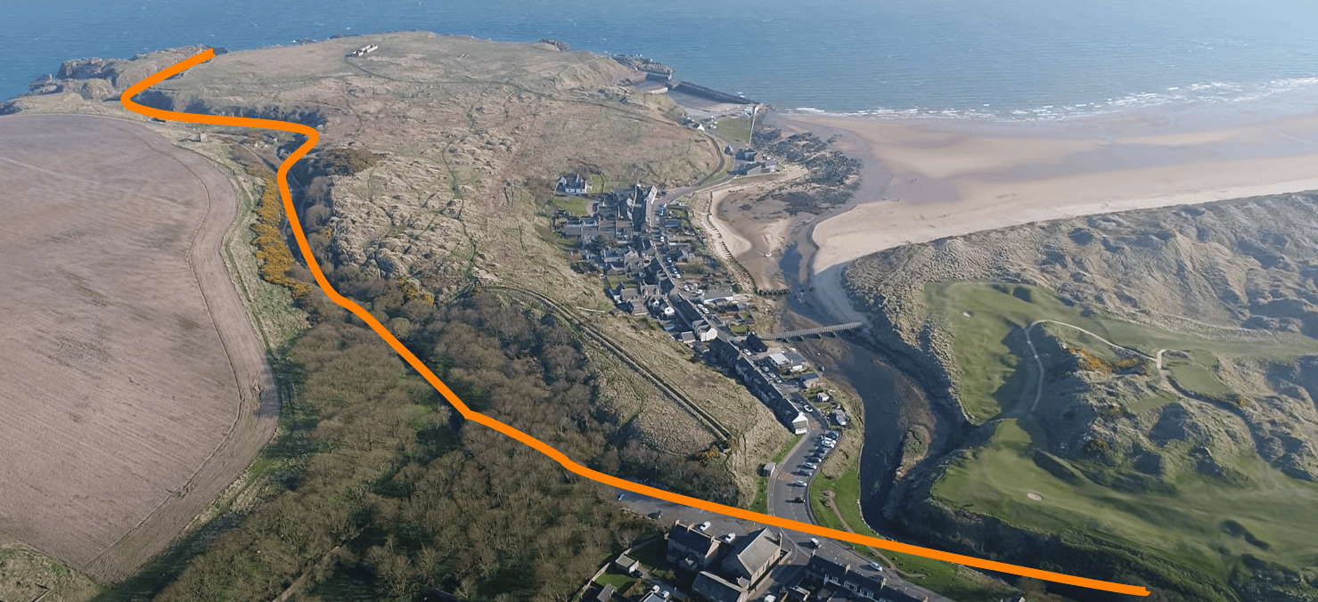
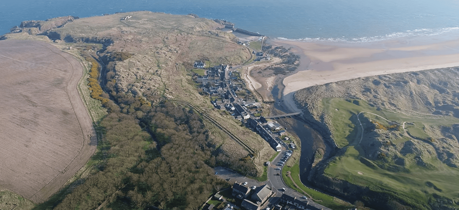

This illustration shows both the current and former routes of the Water of Cruden. The present-day course, highlighted in yellow, passes beneath the bridge on Bridge Street before turning south at the Dardanelles and continuing towards the sea.
It also shows the river’s historic route through the area now occupied by the car park at the end of Main Street, before flowing into Castle Woods, where it would have joined the Back Burn and continued its journey towards the North Sea via the Old Water Moo.
The Forgotten River

So, have you been paying attention?
What have you learned from our journey into the fascinating history of the Water of Cruden and its changing course?
From the centuries-old maps showing the river flowing north to the rocky gorge of Old Water Moo’, right through to the memories recorded by Victorian surveyors and the nineteenth-century efforts to keep Port Erroll Harbour clear of sand, there is a lot of extraordinary local history to uncover!
Why don’t you see how much you’ve remembered by taking part in the brand new Cruden Bay Life Quiz? Test your knowledge of this remarkable Aberdeenshire landscape mystery and see if you are an ultimate local history buff. Just click the button below to get started!
Principal Sources
- William Roy Military Survey (1747–55)
- James Robertson’s Map of Aberdeenshire (1822)
- John Thomson’s Atlas of Scotland (1832)
- First Edition Ordnance Survey (1872)
- Aberdeenshire Ordnance Survey Name Books (1871)
- “A Missing Burn”, Coutts Web
- Modern aerial imagery and field observations
- Open Street Map
Image References
The illustrations and maps accompanying this article have been created to help explain the changing course of the Water of Cruden and its relationship with the surrounding landscape. They are based on historic mapping, modern aerial views, and the visible features that remain around Port Erroll, the Back Burn and Old Water Moo’.
Where modern images have been adapted or enhanced, this has been done to make the former and present river courses easier to understand. They should be viewed as visual interpretations of the available evidence rather than exact historical reconstructions of how the landscape appeared at the time of the diversion.
About Cruden Bay Life
Cruden Bay Life is a digital storytelling project celebrating the history, folklore and landscapes of northeast Scotland. Our articles combine historical research, local tradition, original photography, AI-assisted artwork, music and modern storytelling techniques to bring forgotten stories to life.
Where historical evidence is incomplete, we clearly distinguish documented fact from local tradition and informed interpretation. We welcome constructive feedback and are always happy to correct genuine factual errors as new information becomes available.
Learn more about how we research and create our stories. Click here →